 Canada Journal – News of the World Articles and videos to bring you the biggest Canadian news stories from across the country every day
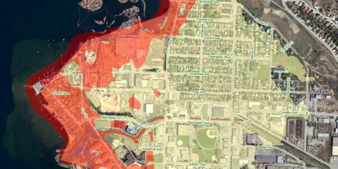
New maps are available on cordemergency that show areas at risk for flooding with no protective measures in place should the lake rise to the new flood planning number of 343.50 metres above sea level.
Map colours indicate areas within the Central Okanagan that are at risk for flooding – from both surface and ground water. Pink shows the potential lake level if there were no flood protection measures in place, and yellow denotes the high water table and influence from rising ground water. Areas at risk include waterfront properties, properties located at the mouth of creeks and rivers, as well as low laying areas.
An additional map identifies properties at added risk of waves from north and south winds. Residents in these areas should build or reinforce protection measures an additional 60cm to a height of 344.10m. However, every property is unique and history is a good indicator of potential wave action. People should protect their property accordingly and give consideration to record high lake levels.
Residents who think that they are at risk should install or bolster flood protection measures, like sandbag dikes, as well as remove valuables from basements and crawlspaces. For more information, visit www.cordemergency.ca/beprepared/flood-faq.
Ground water levels are often a week or two behind increases to lake levels, so residents should monitor lake levels and their properties to help anticipate their flood risk.
Maps are a guideline and a number of variables will contribute to flooding risk, including soil type, saturation and building age.
Central Okanagan Emergency crews continue to assess, repair and fortify flood protection measures in place.
Residents and visitors are reminded to stay off flood protection measures. Jumping or walking on gabions or water dams is a public safety concern and could damage or undermine the device causing ruptures and significant water flows.
While committed to responding to the flood risks, Emergency Operations Centre (EOC) personnel are also planning for the demobilization and recovery period. Residents should keep all flood protection measures in place until the EOC issues information on what actions to take to begin the recovery.
All Evacuation Alerts and Orders remain in effect, and residents in those areas should be prepared to leave on short notice if conditions change and there is a threat to public safety. Visit www.cordemergency.ca/map to search by address to determine if an area is under alert or order, or to find the closest sand and sandbag locations.
Agencies/Canadajournal