 Canada Journal – News of the World Articles and videos to bring you the biggest Canadian news stories from across the country every day
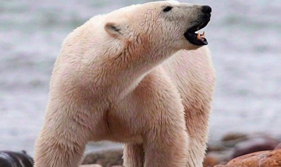
For polar bears, iconic Arctic animals that are coping with diminished sea ice and a rapidly-changing habitat, population numbers are important. But for biologists trying to learn those numbers, the job of counting white bears in a vast white landscape is difficult, expensive and sometimes dangerous.
Now, polar bear researchers from the U.S. Geological Survey and other organizations have found a potential solution — a method of using high-resolution satellite imagery to count polar bears from space.
“We tested the use of satellite technology from DigitalGlobe to count polar bears by tasking the satellite to collect photos from an area where we were also conducting aerial surveys,” said Dr. Todd Atwood, research leader for the USGS Polar Bear Research Program. “We then analyzed the satellite and aerial survey data separately and found that the abundance estimates were remarkably similar.”
The study, which is led by former USGS scientist and current University of Minnesota researcher Dr. Seth Stapleton, is part of an ongoing effort to identify non-invasive technologies to better understand how polar bears respond to the loss of sea ice due to a warming climate. This study tries to determine the number of polar bears and where they reside on Rowley Island in Nunavut’s Foxe Basin during the ice-free summer. “We selected Rowley as our study site because bear density is high during summer and the flat terrain provides an ideal setting to evaluate the use of satellite imagery,” said Stapleton.
Traditionally, scientists study polar bears by capturing and tagging them or by conducting aerial surveys with low flying aircraft. While these methods provide a wealth of important information, they are disruptive to the animals and are often not possible when dealing with remote locations. “We think satellite technology has the potential to open vast, remote regions of the Arctic to regular monitoring. It has tremendous potential to aid the circumpolar management of polar bears,” said Stapleton.
The next steps in the research focus on testing the satellites’ ability to detect polar bear populations over larger areas, including sites along coastal Alaska. Using satellite imagery shows incredible promise and provides one more tool for those interested in preserving polar bear populations for future generations.
Agencies/Canadajournal