 Canada Journal – News of the World Articles and videos to bring you the biggest Canadian news stories from across the country every day
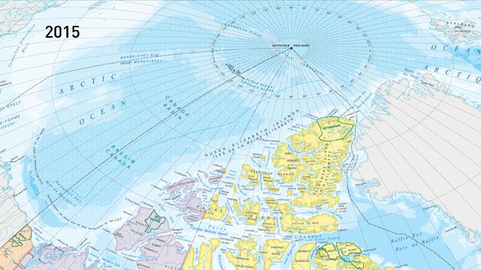
The new official map of Canada is raising some eyebrows this week, as – contrary to reality – it appears to show an increase in Arctic sea ice over the previous map from 2006.
Natural Resources Minister Greg Rickford unveiled the latest edition in the Atlas of Canada Reference Map Series on Wednesday.
A media release states the map represents the federal government’s “ongoing commitment to accurately depict Canada’s landmass and territorial waters.”
That mission includes marking out sea ice in a way that makes it look like there’s more today than there was in a previous iteration, The Globe and Mail reported.
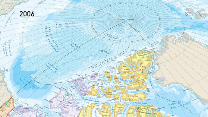
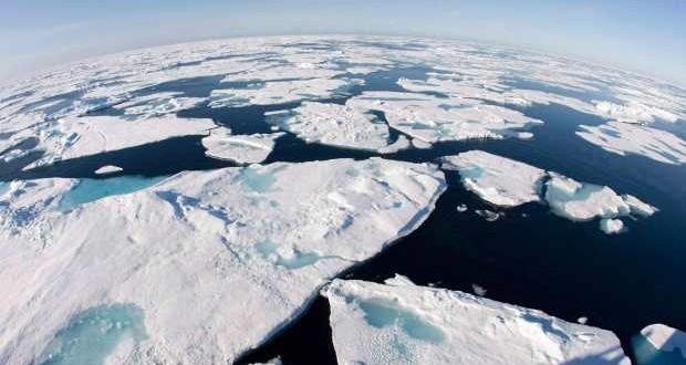
The new map clearly shows more sea ice over the Arctic Ocean, with change readily apparent just north of Alaska and the Yukon.
It appears this way because the map was designed using a 30-year median of sea-ice extent in September of every year, from 1981 to 2010.
Sea ice levels are at a minimum in September.
Meanwhile, the 2006 map showed permanent sea ice that covered northern waters throughout the year, the Globe said.
“Both are correct,” Christopher Storie, president of the Canadian Cartographic Association, told the newspaper.
“They’ve provided the right notation for the representation, but not many people will read that or understand what it means.”
Natural Resources Canada director Yvan Désy added that the map shows sea-ice extent the way it’s calculated by Environment Canada.
But that’s unlikely to please climate change activists alarmed at how much Arctic sea ice has melted over the years.
Data from the U.S. National Snow and Ice Data Center (NSIDC) shows that sea ice in the north over the past winter was more than a million square kilometres below the 30-year average, its lowest level since 1979, when satellite records started being kept.
A UN panel of climate scientists has blamed global warming for an estimated 3.8 per cent decline in sea ice per decade since the records began.
Summertime sea ice in the Arctic circle could disappear by the second half of this century, they said.
The federal NDP requested an emergency debate in Parliament earlier this year when news about record low sea ice first broke in March.
“This is an actual emergency,” environment critic Megan Leslie said.
Agencies/Canadajournal